


2023 Cinco de Mayo Planting Recommendations
For the Northern Philly ‘Burbs

NB: If you are not a member of my Facebook gardening group, you can find it here.
And so friends, the time has come to offer my first round of advice on transplanting warm weather seedlings, and input on related near-term decisions for the 2023 growing season. As always, this is just one person’s semi-informed judgment, mixed with some wild hallucinations and PTSD-ish flashbacks to plants lost to late-season cold. I’ve been wrong in the past, and I will be wrong again. But, in the end, I think my system is more reliable than arbitrary dates (“Mother’s Day”, etc.), and it also opens up the possibility of planting a little early some years. Keep reading to see if this is such a year.
Also, keep in mind that we are talking about warm weather plants, like tomatoes, peppers, eggplant, green beans, squash, cucumbers, etc.. etc. Cool weather growing season (lettuce, greens, radishes, peas, etc.) has been in gear for a month or two already. And, finally, keep in mind that this advice deals with what is possible to do, not necessarily what is advisable. Warm weather plants are called that for a reason – they really prefer warm weather. Most will tolerate some cool nights, but they really prefer warm days and comfortable nights.
So my advice here is directed primarily at folks who simply cannot wait, and who don’t necessarily care about waiting for ideal conditions. These folks want to plant on the first day where it is reasonably certain that their tomato plants won’t be seriously damaged by cold weather. For the more patient sorts, make this easier on yourself and your plants – just wait until late May. The exception to this advice is if you started your plants too early, and they are beginning to show signs of stress. In that case, the benefits of being in soil will outweigh the drawbacks of some cooler nights. More on that later. But keep that calculus in mind, and evaluate your own situation.
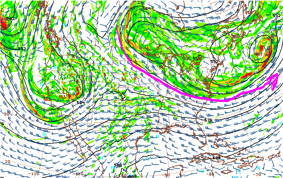
So let’s get to the forecast. The picture below is one weather model’s depiction of what is going on way up high in the atmosphere right around now. I drew a pink line to highlight a large area of low pressure that has been plaguing the northeast quadrant of the continental US and parts of Canada all week. That’s what brought the rain last weekend, the unseasonably cold temperatures all week, and the on and off sun and showers. The reason you get the roller coaster in these situations is that cold air is heavy, and all that heavy cold air way up in the atmosphere leads to instability.
But enough of that. The point here is that huge “upper level low”, as the real meteorologists call it (of which I am not one), is finally about to say “buh-bye”, hallelujah, praise the Lord. As it departs into the Atlantic on Cinco de Mayo and into Saturday, there will be a noticeable change in the feel of the air. It is just going to feel more comfortable, for you, and for your plants, particularly as we get to Sunday.
Speaking of which, here’s what the same upper air chart looks like for Sunday:

Whoa! That’s much different. Now we have what’s called a “ridge” building in to replace our upper level low. Or as the late, great Jim O’Brien used to put it on Philly Action News, we got a good guy replacin’ a bad guy. And it’s hot as a hyena’s bottom in Truckee, California (that last bit was for effect – I have no idea what it’s like in Truckee, California right now). Actually, ol’ JO’B used to like to say “Casa GRANde” with gusto, when the high temp for the day occurred there – or even if it didn’t. That’s in Arizona. But I digress.
So what’s the point? Well, I’m just priming the pump here to show you how these upper air charts usually sorta kinda correspond to your experience of the weather. The past week has been preeeettty crappy and cold for May, and you have that first graphic to blame. Sunday is going to be preeeettty nice – and that second upper air chart also tells that story.
So at this point you might be saying “Hey Tom, what about lower air charts and middle air charts? Ya got any of those?” Well, I do, but cool people don’t call them that (if you want to sound like you’re lit at a party full of meteorologists, if such a thing even exists, use the phrases “surface layer” and “850 millibar chart” a lot. Then they’ll stop trying to avoid you, because they’ll know you’re not normal ...like them).
So, yeah, what the heck, let’s kick it down a notch and look at the 850 millibar chart for the middle of next week:

See that purple line that my pink arrow is pointing toward? In the winter months that line (and thus this chart) is very important because it is a general guide to the rain/snow line during winter storms. Of course, we haven’t had one of those in a right long time in these parts, so I haven’t spent a whole heck of a lot of time looking at 850 millibar charts this season. I dredge one up here because there’s more to the story than rain/snow lines. And in this case the story is a trend. A few days ago, the model was more bullish on the southern reach of that purple line. That meant that there was more of a chance of some cool overnight temperatures in the 5/10 to 5/12 time frame (a “back door cold front”, if you must know the weather geek lingo). And that was the first danger zone that I needed to track before making a call for all you overzealous gardeners out there who planted your tomato seeds way too early, against my advice.
Bottom line, I think we can write that one off as a potential worry. So let’s fast forward a bit. Before I do, I suppose I should explain the premise of what I’m doing here. First, what they call the “operational” weather models only go out a couple weeks (sixteen days). And, frankly, it’s a crap shoot after five or six days, and, for most applications, next to worthless a couple weeks out. But this isn’t such an application. Because we’re not really trying to predict the exact weather sixteen days out; all we’re trying to do is rule out any weird, anomalous invasions of cold air from Canada. And we really only need to do that out to a certain point -- because, honestly, it very rarely gets cold enough to matter once you get into the last week of May. So that’s our strategy here.
Anyway, let’s fast forward to around 5/17 and see what our 500 millibar chart (that’s “upper air” to you) is doing:

Ruh roh! What the heck is that???!!! Well folks, that is another upper low, much like the one we just experienced -- and a very energetic one at that. Sure, it’s spinning around the Hudson Bay, and well out of our weather picture. This is true. But the model is seeing something significant, and placement of these features two weeks out is fraught. We have no real idea where that thing will be in two weeks, or even if it will definitely exist. Move it south a couple hundred miles, and suddenly we have a couple 45 degree nights and cold, windy afternoons to contend with. Yuck. By the way, I am just as concerned with wind as cold. A cool, blustery, March-like day can do a lot of damage to a newly-planted seedling. Wind would not be a huge problem as depicted -- but, again, if that thing moves south a bit, then wind suddenly becomes a major issue.
So my recommendations on this fine Cinco de Mayo morning boil down to how to interpret and leverage this rather unwelcome feature on the models. The best I can tell you is what I plan to do personally. For starters, I have one larger tomato plant and a number of smaller ones. There is no need to plant the smaller ones just yet, so why should I take any chances by planting them this weekend? They’re fine in their pots; in their pots they will stay for now. If the long-term forecast changes by next week, fine, they can go in the ground then. Same with my one eggplant, which is still very happy in its pot. What’s the rush? I would likely go ahead and plant the larger tomato plant on Sunday, if it were rootbound, and just plan to cover it if needed. But it is in a large pot and doing fine. Again, no rush. It can stay outdoors in the pot, and I will reassess (and update this post) in a few days.
On the other hand, my pepper plants are large, and it comes down to either putting them in the ground or repotting them. And I don’t feel like repotting them. So those will likely go into the ground on Sunday 5/7. Pepper plants are weird; they like more sun and heat than tomatoes (which, contrary to lore, actually appreciate a little break from the summer afternoon sun), but they can also take cooler nights a little better, if hardened off. So I will likely roll the dice with those and just cover them if the evil upper low depicted on the charts comes our way in a couple weeks.
What about other stuff? Here’s what I will and will not be doing:
Sensitive house plants are staying inside for now (unless you feel like giving them some outdoor time during the day just to start the transition).
If I had a bunch of flower plants laying around rootbound in flats (which I don’t, but I’m sure some of you do), I’d just go ahead and plant them this weekend. Again, the calculus of current root state vs. future weather possibilities informs this.
I am waiting to sow beans, pending updated weather data next week.
I’m not growing corn this year, but I would evaluate local soil temperature with that, and forget about my fancy weather charts.
I will be starting squash and cucumbers in pots. I’m a little late to the game there, but still not 100% comfortable direct sowing them. I will hedge my bet and sow in pots, thank you.
I will probably go ahead and sow some dill and cilantro directly into the garden
I will likely transplant my first-round basil plants into the garden because they are rootbound, and I have newer plants on the way anyway.
I’ll probably do the same with my parsley, because it can take any cool weather just fine. The only reason they are still in pots is that they are still on the small side.
I have some sunflowers in pots under lights. They’re still young, so I will just move the pots outdoors. If they were larger and rootbound I’d probably just plant them. The other issue with sunflowers is that they are prime targets for major animal damage (“major” being defined as “leave a worthless stem sticking up out of the ground”), and I probably would not have the time to protect them properly if I planted them this weekend.
So, in sum: I would go ahead and plant any highly rootbound garden plants this weekend. For stuff that is still growing into its pots, and seemingly happy with its current lot in life, I would leave it there pending updated info on weather conditions in the 5/17-19 time frame. Which I will offer next week, so stay tuned.
Have a great weekend.